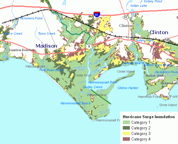
This information includes Hurricane Surge Inundation areas for category 1 through 4 hurricanes striking the coast of Connecticut with a peak hurricane surge arriving at high mean water. The hurricane surge elevation data used to define these areas were calculated by the National Hurricane Center using the Sea Lake and Overland Surge from Hurricanes (SLOSH) Model. The SLOSH model hurricane surge elevations have an accuracy of +/- 20 percent. The hurricane surge inundation areas depict the inundation that can be expected to result from a worst case combination of hurricane landfall location, forward speed, and direction for each hurricane category. For additional documentation including a description of the map legend, refer to the CT ECO Complete Resource Guide for Hurricane Surge Inundation.
Hurricane Surge Inundation area data are developed to assist federal, state and local emergency management officials planning for and responding to hurricanes.
The Sea, Lake, and Overland Surges from Hurricanes (SLOSH) model was developed by the National Weather Service to calculate potential surge heights from hurricanes. The SLOSH models for Connecticut were run by the Storm Surge Group, National Hurricane Center, National Centers for Environmental Prediction, National Oceanic and Atmospheric Administration, Miami Florida. The SLOSH model calculates the hurricane surge elevation that would result from over 500 combinations of hurricane category, landfall location, forward speed, and direction. Hurricane surge elevations were determined by the National Hurricane Center using the NY2 and PVD SLOSH model basins, and assumed peak hurricane surge arriving at mean high water.
Users should recognize that there are accuracy limitations inherent to each of the data sources used to create maps that depict the hurricane surge inundation areas. The SLOSH model hurricane surge elevations have an accuracy of +/- 20 percent. The vertical accuracy of all LiDAR elevation data is approximately +/- 1 foot, and the horizontal accuracy is approximately +/- 3 feet. When displayed in the background for reference, the river, stream, lake and pond features included in the hydrography data from the Connecticut Department of Environmental Protection are only suitable for mapping at scales not more detailed than 1:24,000 scale (1 inch = 2,000 ft). The horizontal (positional) accuracy of the shoreline shown for hydrography features is less accurate than the horizontal accuracy of the LiDAR elevation data used to generate hurricane surge inundation areas so discrepancies exist when these are both shown together on a map. Also, similar discrepancies can be expected to occur even between more horizontally accurate street and orthophotography data and the hurricane surge inundation areas.
Therefore, the maps should be used as a general guide, rather than an absolute representation, as to which areas can expect to be inundated (flooded) by worst-case hurricane storm surge for a particular hurricane category. In addition, users should note that there may be areas that are not shown to be inundated by hurricane surge, but are in fact surrounded by hurricane surge. Those areas may become isolated by hurricane surge.