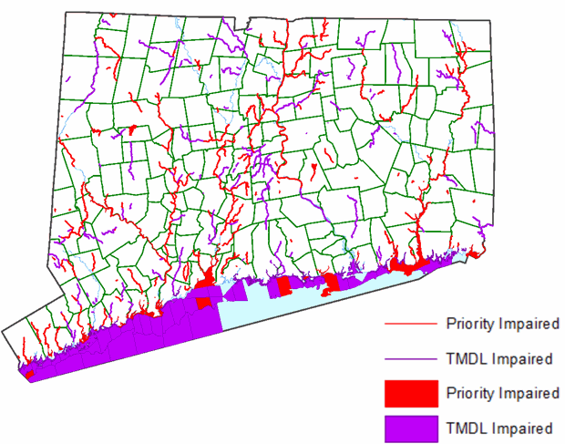
The stormwater impaired waters layer is based on the 2018 Connecticut Integrated Water Quality Report (IWQR). All waters (rivers, lakes, estuaries) that were listed as impaired (EPA Category 5) in Appendix B-1 of the report and all waters that were listed as having an adopted TMDL in place in Appendix B-2 were identified. Both lists were then compared to the Impaired Waters guidance in Appendix D of the 2017 General Permit for the Discharge of Stormwater from Small Municipal Separate Storm Sewer Systems Reissuance with Modifications. Waters with adopted TMDLs in the 2018 IWQR for the stormwater pollutants of concern listed in Appendix D (phosphorus, nitrogen, bacteria, mercury) of the General Permit and those with a cause listed as ‘Impervious Cover’ were then identified and added to the Stormwater Impaired Waters layer. Impaired waters without a TMDL in the 2018 IWQR were reviewed and those with causes matching the causes listed in Appendix D for each stormwater pollutant of concern were added to the Stormwater Impaired Waters layer. Waters in Appendix B-1 of the IWQR that indicated any of the causes listed for Phosphorus or Nitrogen were listed as impaired for Phosphorus and Nitrogen per DEEP decision. Waters in Appendix B-1 of the IWQR that indicated the impairment cause was ‘Turbidity’ or ‘Unknown’ were listed as impaired for Other pollutant of concern.
The resulting list of stormwater impaired waterbodies were then matched up with the Connecticut 303(d) Impaired Waters 2018 (rivers, lakes and estuaries) waterbody features using the waterbody id. Information including stormwater pollutant of concern, cause, impaired designated use and TMDL can be identified by clicking on the layer(s) in the MS4 viewer or with the identify tool in a desktop application. Additional information about Integrated Water Quality reporting is available at the CT DEEP website.
Purpose: CT 2018 Impaired Rivers is 1:24,000-scale data. It depicts stormwater impaired waters layer is based on the 2018 Connecticut Integrated Water Quality Report (IWQR). This layer should be used with the other assessed waterbody layers: Stormwater Impaired Estuary and Stormwater Impaired Lakes. This layer should only be viewed with other 1:24,000-scale map data such as water quality classifications, roads, towns, topographic quadrangles, and digital orthophotos. Not intended for maps printed at map scales greater or more detailed than 1:24,000 scale (1 inch = 2,000 feet.)
Additional information about Integrated Water Quality reporting is available at the CT DEEP website.
This information is available in the MS4 Map Viewer and on the Connecticut MS4 Guide website.